Like many people I suspect, I spent most of Thanksgiving playing the new Elder Scrolls computer game Skyrim. The Elder Scrolls has always had an interesting skill based system that I thought might make a good paper and pencil RPG. This time they have boiled the stats and skills down to the mere essentials. Only three stats Magicka, Health, and Stamina. Eighteen skills broken down into three categories
Combat: Smithing, Heavy Armor, Block, Two handed, One Handed, and Archery
Stealth: Light Armor, Sneak, Lock picking, Pickpocket, Speech, and Alchemy
Magic: Illusion, Conjuration, Destruction, Restoration, Alteration, and Enchanting
I think 5 schools of magic much more wieldy than D&D traditional eight, and most of them seem to be well balanced in power. I need to remap the spells into a more d20 format.
I like that each of the paths has its own route for making things. I think the alchemy part is the one system I enjoy most although its a lot of book keeping for a pen and paper game, perhaps I just need to pass out reagent points as treasure. Enchanting runs a close second, although I'd just give out charge soul gems as treasure rather than having to charge them. I have yet to put together the evil little axe I used in Morrowind to conquer the world, it gave the damage it did back as health for me, the Gaulador Black blade seems similar but it does only 10 health per hit, and is constantly running out of charges. Smithing is O.K. but maybe not as powerful as the other two (or perhaps I haven't got the knack yet). I do wonder who makes all the pots and pans, clothing, wooden bowls, cups ecetera since all you can make is armor, perhaps I'll go back to 3rd editions craft. I will NOT be using 4th edition's "yeah you can make that, just mark of the gold you would spend to buy it" system.
Rather than use a check every time you use a skill (due bad experiences with Runequest) I think I'll go with using experience to buy skill levels. Skill checks will be done by rolling a d20 and adding you skill to beat a difficulty (not sure how the computer does it). I have to reserve judgement on the skill perks system until I understand it better. Playing my traditional battle mage wearing heavy armor and swinging a one handed axe, while throwing spells with the other I ended up with my perks scattered all over the map, including a few throw into enchanting and smithing. A more optimal character would be focused in a few skills and just buy stuff from NPCs, but who'd make the Fortify two handed while having 13% weakness to frost, and 4% barter increase potions then (Strangely enough the NPC seem to pay extra for the extra properties, and I'm more than happy to sell it to them 'cause I sure as heck ain't drinking it). Well I think the big computer is done rebooting, so its back to the land of Nords for me again. Unfortunately, either the graphics card or the sound system is a bit unstable cranking out the horse power needed for Skyrim, so its save early, save often and reboot as necessary. Fortunately I have played many such games before and am patient, I figure its just the computer saying "O.K. its time for a break to do other things".

Tuesday, November 29, 2011
Tuesday, November 8, 2011
Every man a once and future King
Finally made it through King Arthur the truth behind the legend by Rodney Castlon. I have had an interest in the real King Arthur since writing my high school research paper on it, using a different book by Geoffry Ashe for most of the facts. Chock full of interesting facts and tid-bits. Chapter one boils the hard evidence down to two mentions in the Easter Annals. Chapter Two is a very thorough going over of the literature we do have, including stone markers, genealogies of Welsh and Irish Kings, and poetry, as well as books. An 1120 manuscript is the source for both The Easter Annals and Nennius's Historica Brittonum. Although Nennius wrote his part in 830 A.D it is proposed that the Easter Annals were added later, about 960-970 A.D. Nennius draws from several earlier documents and has been somewhat discredited in that he already including some of the more mythological elements in his descriptions of Arthurs life. Gildas's Book of Complaints written about 540 AD does mention the battle of Badon, Arthur's victory over the Saxons, but fails to mention Arthur. Even more troubling is that Arthur may actually be a nickname (Welsh for bear = arth). Gildas does mention one of his contemporary kings as "the driver of the chariot of the bears stronghold". The Anglo-Saxon chronicle written by the other side is most notable for a lack of much expansion during the 50 years of the supposed time of the battle of Badon. It of course fails to mention Arthur or even the battle of Badon itself. All of this may seem like skimpy evidence, but given my experiences with histories of this time period I am inclinded to give Arthur the benefit of the doubt (After reading an interesting book on the battle of Caane, you know the famous battle battle where Hannibal whipped the Romans, which points out the main record we have of it is a history written 80 years after fact by the grandson of one of the generals, I am inclined to examine ancient history with a lax view to the documentation). The rest of the book dispenses with trying to further verify the existence of Arthur and launches into a description of what we do know about Sixth century Briton. She-who-must-be-obeyed has promised a battle map of one of the hill forts proposed as a location for Camelot complete with hall (know from the post hole pattern). Unfortunately since Camel is Briton for windy, there are a lot of river Camels in Cornwall and Wales. There are also a great many kingdoms, apparently the Britons didn't have mayors, sheriffs, or village elders, just kings. Gildas points out that if the Briton kings had spent less time fighting each other, they might have done a better job of beating the Angles and Saxons. One of my favorite parts of the book is its description of Tintagel, part Castle, part Christian Church, and part pagan ritual site. I especially like the carved foot print in the rock, that book speculates was used by ancient Kings to swear allegiance to the land. There is also the tunnel carved in the rock leading nowhere, a grave that is purported to change size periodically, and numerous other oddities. All in all an interesting dive into the historic Arthur. The back has a bibliography of numerous other books on the historical Arthur, apparently British scholars have been at this subject a while.
Wednesday, October 12, 2011
Zatoichi versus Yojimbo
***Warning Spoiler***
Re-watching one of my favorite samurai flicks "Zatoichi versus Yojimbo". I keep thinking the'res got to be a D&D adventure in there somewhere. Zatoichi after a harrowing escape in the rain decides to head for a peaceful village of the beaten path, which he remembers for the smell of plum blossoms, the babbling brook, and the cool breeze. When you see the dead body floating in the brook that Zatoichi doesn't see being blind, you know things aren't going to go well for Zatoichi (they never do). Turns out some crumb bums are stealing gold by clipping coins at the Shoguns mint, and hiding it here in this out of the way village. Unfortunately it seems that every villain within a hundred miles has heard the rumors. Plot is driven by strong characters: Zatoichi the blind swordsman who keeps trying to do good, but usually ends up cutting everyone to sushi. Yojimbo who pretends to be a drunken mercenary, but is actually a secret agent for the Shogun, and then there's the third guy who's sent by the Shogun to see whats taking Yojimbo so long, he's got his own secret army and a two shot pistol for when he doesn't feel like slicing people in half. The main plot problem I encounter for samurai flicks is of course rather than working as a team like a good D&D adventuring party the main characters end up squaring off to see who's the better swordsman. Zatochi and Yojimbo both draw blood when fighting but avoid killing each other. Unfortunately Yojimbo kills pistol guy so no sequel for him.
"Incident at Blood Pass" is another of my favorites with a somewhat similar plot, but this time the gold is just passing through and no blind swordsman, only the drunken samurai. How about you? Ever figure out how to convert a samuria flick into an adventure? How'd it work out.
P.S. One thing I like about samuria flicks not many reoccurring villians. Once the two guys draw swords, usually only one of them is walking away.
Monday, September 19, 2011
Mega Dungeon Format
Comments on the Megadungeon format question posed by a fellow blogger at Grognardia a few weeks ago:
My favorite megadungeon format the "Ruins of Undermoutain" boxed set:
Large poster map for the dungeon
Book of special keyed encounters
Book of random role-up encounters to fill in the rest
It's pretty close to all you need.
My least favorite megadungeon format "Return to Undermountain"
Everything in one book so you have to flip back and forth between the maps and the encounters
Map arted up to make them unreadable and CROPPED!?
No non set piece encounters, as matter of fact everything off the linear railroad plot blocked off with rock falls to ensure no "sandboxing" ever
As my friend refers to this module "a little tiny crappy piece of Ruins Undermountain"
The second edition large boxed sets remain some of my most favorite adventures the "Ruins of Myth Dranor" is a close second to "Ruins of Undermountain" although it is not a classic megadungeon. The one thing Myth Dranor adds to the repertiore is the mini-dungeons on cards which gives the DM some flexibility, however I recommend against printing the key on the back as this leads to a lot of card flipping.
Saturday, August 27, 2011
Ultima Underworld 2
So I have lost a month playing an old computer game. My son quite frequently decides that we need to play '90s Dos games, and we had a two-for sitting around which included both Ultima underworld (which we have played a great deal already) and its companion Ultima Underworld II (which we have not played much). So of course we got the dosbox and dfend out (two great little programs for running '90s games which do a much better job of handling the weird memory gyrations of '90 dos than Microsoft) and began to play. Since my sons approach to playing involves slaughtering everything that moves and letting Dad figure out the clues and puzzles. I have long ago swallowed my pride and realized that the way though most games is to use the cheats and walk-throughs available on the Internet (This is especially handy when all the creatures who were supposed to give you clues are dead, or angry at your attempt to cut them to pieces). So I have been spending a lot of time listening to this German guy as he works his way through.
The Ultima underworld series still has my most favorite set of skills for roleplaying. I am totally stealling it for my roleplaying game (don't hold your breath kiddos, I have been writing my own roleplaying game for over years and not published anything yet).
Sunday, July 10, 2011
The Grid, the Grid
The nice map posted at the City of Iron got me thinking. You see Gavin, the artist, decided to draw his map free hand without a grid, and that got me thinking. If your going to show to the players when I don't see a problem of no grid. If you need to sketch in on a battle map, or describe it verbally for me at least a grid is quite useful. Of course these days drawing the map and adding a grid later is pretty simple (It could be done in the old days but required gridded chartpak and some skill with an x-acto). I usually tried to grid the room floors and leave the walls blank, the opposite of the artists at the White Dwarf and Judges Guild who tended to grid the walls and leave the floors blank. I'll not comment on his choice of red lines with purple shading,as that is a matter of personal preference. Although, if you are running "Old School" and not showing the map to anyone else, I would not spend a lot of time trying to make the map look "pretty". I would however grid it for the reasons already mentioned.
Substistance Farming and the Man
As a complement to my map of village densities in 11th century England, I have been working on a map of village densities in the Old Northwest territory (which Ohio were I live happens to be part of) during the 18th century. I have nice map of village locations in 1759 courtesy of the Atlas of Great Lake Indian History, Helen Hornbeck Tanner ed. University of Oklahoma press 1987. However, I have run into to issues. First, the Old Northwest territory is too big to map comfortably with five mile hexes. Second, after over 200 years of warfare and smallpox, village densities are measured in hexes per village rather than villages per hex. As such I had set this project aside for a bit.
My recent posts on the Aztecs have let me back to thinking about Native Americans once again. While researching Aztec farming techniques at the library, I peaked over at the Native North American section right next door and obtained The Miami Indians of Indiana, Stewart Rafert, Indiana Historical Society. The Miami, a small tribe, feature prominently in Atlas of Great Lake Indian History for their control of the portage (now Fort Wayne, IN) between Lake Erie and the Wabash River (a substantial short cut to the Mississippi River if you are traveling by Canoe). Since Miami Indians of Indiana was an easy read and allowed me to procrastinate further on the turgid but important sounding Cultivated Landscapes of Middle America on the Eve of Conquest I read it cover to cover. One of the most fascinating parts of it is the tribe continuing to live its lifestyle of the men hunting and fishing, and the women growing a little corn and a little squash on a mere 10 square mile reservation IN INDIANA from 1847-1872 (a population of roughly 148-250 people over the time period). I am a bit surprised since 10 square miles (6,400 acres) is only a little bigger than one our modern factory farm which will have 10 people living on it if the farmer has a big family (not sure how many people it feeds I'll have to look that up). The legal manoeuvrings which allow them to stay in Indiana while the rest of the Native Americans forced west at gun point are also quite interesting (a lot of it has to do with the local non-native American tavern owners and lawyers liking the tap into the yearly U.S. Government hard currency (silver dollars) payment the tribe collected as a treaty settlement. It unfortunately also lead to only the Miami who moved to Oklahoma being recognised as a "tribe" by the U.S. Government. In 1873 the reservation was broken up into 63 farms and divided amongst the residents. Many Miami being brave soles prompt tried their hand more conventional farming. Unfortunately this involved borrowing the $1,000 from the bank to equip a conventional farm and selling the farm to the bank when the inevitable "bad year" hit and bank could not be paid. The 1994 U.S Government wrangling that the guy who ruled in 1895 that Indiana Miami were no longer a tribe was wrong, but since it had been too long (mostly because the Bureau of Indian Affairs ruled in the several lawsuits since the ruling that because the Miami were not a tribe no lawsuit could be brought) is also a prime example of why people of my generation have a great distrust of government (also known as "the Man). There is an interesting corollary between the treatment of Native Americans and the "screw job" conducted by the enclosure of 16th century England, as well as the Oklahoma farmers during the dust bowl, but this post is long enough already.
My recent posts on the Aztecs have let me back to thinking about Native Americans once again. While researching Aztec farming techniques at the library, I peaked over at the Native North American section right next door and obtained The Miami Indians of Indiana, Stewart Rafert, Indiana Historical Society. The Miami, a small tribe, feature prominently in Atlas of Great Lake Indian History for their control of the portage (now Fort Wayne, IN) between Lake Erie and the Wabash River (a substantial short cut to the Mississippi River if you are traveling by Canoe). Since Miami Indians of Indiana was an easy read and allowed me to procrastinate further on the turgid but important sounding Cultivated Landscapes of Middle America on the Eve of Conquest I read it cover to cover. One of the most fascinating parts of it is the tribe continuing to live its lifestyle of the men hunting and fishing, and the women growing a little corn and a little squash on a mere 10 square mile reservation IN INDIANA from 1847-1872 (a population of roughly 148-250 people over the time period). I am a bit surprised since 10 square miles (6,400 acres) is only a little bigger than one our modern factory farm which will have 10 people living on it if the farmer has a big family (not sure how many people it feeds I'll have to look that up). The legal manoeuvrings which allow them to stay in Indiana while the rest of the Native Americans forced west at gun point are also quite interesting (a lot of it has to do with the local non-native American tavern owners and lawyers liking the tap into the yearly U.S. Government hard currency (silver dollars) payment the tribe collected as a treaty settlement. It unfortunately also lead to only the Miami who moved to Oklahoma being recognised as a "tribe" by the U.S. Government. In 1873 the reservation was broken up into 63 farms and divided amongst the residents. Many Miami being brave soles prompt tried their hand more conventional farming. Unfortunately this involved borrowing the $1,000 from the bank to equip a conventional farm and selling the farm to the bank when the inevitable "bad year" hit and bank could not be paid. The 1994 U.S Government wrangling that the guy who ruled in 1895 that Indiana Miami were no longer a tribe was wrong, but since it had been too long (mostly because the Bureau of Indian Affairs ruled in the several lawsuits since the ruling that because the Miami were not a tribe no lawsuit could be brought) is also a prime example of why people of my generation have a great distrust of government (also known as "the Man). There is an interesting corollary between the treatment of Native Americans and the "screw job" conducted by the enclosure of 16th century England, as well as the Oklahoma farmers during the dust bowl, but this post is long enough already.
Monday, July 4, 2011
Swag from Origins
Living pretty close to Columbus, a trip to the Origins dealers room is a family ritual. Not a lot of swag for me as She-Who-Must-be-Obeyed blew one chunk of the budget on Warhammer bits (well technically the Orc bits are for my army), and my son is equipping the 7th Federation fleet (not sure where the battle star will fit in it, but it was cool so we bought it too). Got some free RPG day leftovers as free was definitely in the budget (mostly WoTC, but Goodman's Dungeon Crawl Classics Starter as well). Limit on free RPGs was two per customer, but this is where having a wife and son with me paid off (my son used one of his picks for something a space ship on the cover). Picked up the new hardbound Arcanis (enjoyed the beta test version I picked up at Gencon last year so thought I'd give it a go). I'll post a full review sometime soon. Was severely tempted by the Hackpedia of Beasts pre-order, but gave it a pass. I am glad it is all in one book, unlike the book 1 A-C, book 2 D-F, etc of the previous edition (I gave up about L). However, I remembered how unimpressed I was with the monsters in the previous edition (suffered from me-too-ism by re-replicating all the monsters in the d20 SRC with little change). I also don't really need to be buying books just to throw in the box of Hackmaster rules gathering dust in the corner (Hackmaster and I don't see eye-to-eye on taking the core d20 rules and making them more complicated). And finally the real find of the show, White Dwarf 34. I have been after this bad boy ever since She-Who-Must-Be-Obeyed ran me through the Starstone adventure in 1983, and we saw the note that White Dwarf 34 contained another module by the same authors "Trouble at Ember Trees ". Five pages of old White Dwarf microprint (I did have to use my scanner to enlarge the print, as my eyes can't handle microprint any more) goodness with FOUR maps and SEVENTY EIGHT encounters. They just don't write'm that way any more. Heck, five pages will barely fit ONE fourth edition encounter. And where did I find this gem? Was it in the glass case at Crazy Egor's (Talisman Timescape another on the "how did I miss that" list was, but the price was too dear)? Was it got from the Troll and Toad auction after some fevered bidding war? No, it was in the $3 bin of old junk we want to get rid of at the Comic book vendor booth. WOHOOOO! some days the collecting gods smile on you.
Friday, July 1, 2011
Curiouser and Curiouser
I am looking at my blog stats and being a bit bemused. My blog had over 9,000 views last month versus a mere 1,000ish the month before. So in a month which due to business travel and the nephews graduation I posted almost nothing I get a ninefold increase in traffic. Whats my most viewed post? A blank piece of notebook paper!
Wednesday, June 29, 2011
Now thats a Map
Updated to fix the broken picture link 3/11/2023
Sunday, May 15, 2011
Spanish Victory for Cortez with help from Friends
One of my commentators to the previous post is certainly correct about the Spanish needing help from native allies. Unfortunately I think that worked out better for the Spanish. The book on pre-Columbian agriculture, I picked up highlights the precipitous collapse of the native population and a shift in farming from using all the varied habitats to just those suitable for planting with a plow or raising cattle. The collapse can be attributed to old world diseases (Guns, Germs, and Steel is a great book on this subject), but the lack of recovery may be more due to the shift in farming. It also interesting that New world seems to have several cultural collapses including the Maya in the 10th century, the Anasazi in the 13th century, and Teotihuacan, about 25 miles to the north of Tenochtitlan (and probably a bigger city as well) abandoned in the 5th century. The Spanish spend some time hiding out in Teotihuacan after being thrown out of Tenochtitlan Central America is certainly a more populous and complex place than the new world campaigns I have run in the past. However, when I try to add complex and interesting large civilizations to my campaign, I am roundly booed by the players for interfering with their exploration and looting of ancient ruins. Perhaps the loudest complainer is She-Who-Must-be-Obeyed who does not see the same drawbacks in her urban based Medieval European campaigns. More on this in another post.
Saturday, May 14, 2011
Tenochtitlan another City of the Pyramid


Saturday, April 23, 2011
City of the Pyramid
At the junction of the great causeway and the great underway lies a nexus of great power. After the fall of the elves during the Golden age it was here the golden ones came to build pyramid temples to their dark gods. Seven tiers for the Burning One, Five for the Breaker of Hope, a mere two for the Mistress of the still pool, an unimportant goddess worshiped only by females and pondlings. Still her pyramid is required to balance the fearsome dread of the uncounted tiers of the underpyramid of the Drowner in Darkness. The Treader of the Secret Ways required no pyramid, stealing his worship by masquerading as the other gods. Once the pyramids were complete the Sorcerer Kingpriests focused their energy to forge the Great Artifact. During the catastrophe the Great Artifact was split into to the sphere, the cube, and the tetrahedron. As the artifact was split into three so were majority of the golden ones, into the kobolds, lizardmen, and weygn. Their ensuing battles to reunite the Artifact soon destroyed the city, and the inhabitants dispersed into the black swamp which broke the canal walls and swallowed the city whole. Their descendants still squabble, fight, and dream of reuniting the artifact to restore the glory of the Golden age. A mere half days journey from the newcomers Clerics Post on the Great river, the ruined city still lures adventurers to doom and glory. The lizardman "people of the turtle" will lead you there for a few trinkets, but warn that the "people of the shark" who inhabit the ruins proper are not as friendly, and are only fond of strangers as barbecue. Below is the mosaic in the chamber of the map showing the city as it was in the Golden age.


Note: The City of the Pyramids served as my anchor dungeon for my great river campaign of the early '90s. She-Who-Must-be-Obeyed still remembers this campaign with fondness.It was a bit of a breakthrough in style for me as well as I replaced my megadungeons of the past with little 3-5 room mini dungeons which could be completed in a night or two. However most of the mini-dungeons remained connected by the Great Underway a 30' wide straight barrel vaulted corridor leading on for miles leading god knows where (although one was bound to stumble on to a secret door leading to the next mini-dungeon just in time for the next session). Due to its connection to the Great Underway my wandering adventurers found themselves in the City of the Pyramids more often then they would have liked.
Tuesday, April 19, 2011
A is atmosphere, F is for flame on, Z for zzzzzz (loud snoring)
Ok I have completed the complete alphabet in a single post, can we move on. Maybe is the fact that its tax day (as usual I did just enough to make sure Uncle Sam owed me money and pushed it off to October), or maybe its the fact that the stats show that a blank piece of note book paper has shot up to my third most popular post (someone on stumble-on though it was cute), but I feel the urge to complain about the mindless A-Z meme that has inflected my Old School Renaissance. Most blogs are luckily if they can get one post out a week, but it is usually from the heart and thought provoking, but the A-Z meme has led them to believe they can up their production to one a day with some meaningless trivia. Most of them are sputtering out about O, so soon things will be back to normal, and I can stop skipping over posts at greater than the normal rate. I of course did have to look at P is for Prostitute at Appendix N (little imredave wanted to see it, however he was disappointed). Appendix N does point out that "Old School" it should be H is for Harlot. It did bring back memories of a certain adventure in She-Who-Must-be-Obeyed running of the city of Karse. We had turned down an alley way into a small square, and encountered a lizard woman in fish net stockings leaning up against the wall near the entrance to the bar, clearly indicating we were no longer in the high class neighborhood. Since we were in desperate need of a certain substance from a certain alchemist shop across the square we pressed on. We were also not surprised when the 1st level got shanked (We were surprised later to find out it was one of our party members who shanked him). She-Who-Must-be-Obeyed later reviewed her notes to find out a little more about the lizard lady, and discovered that all it actually said was "Rough Bar". Such is the power of imagination. Well its time to go to work, so this rambling flame must end. Next time something of substance.
Saturday, April 2, 2011
Multipurpose Wilderness/Dungeon Planner, DM Reference, and Char Sheet
What we used for wilderness and dungeon planning, dungeon master reference notes, and character sheets, and many other purposes
Old School:

Old School:
My little joke for April 1st, but also true.
Friday, April 1, 2011
Dungeon in the Raw
Here's a dungeon I call "Palace of the Dragon Prince". I sketched it out a couple of weeks ago in hopes of cleaning it up and entering it into the one page dungeon contest. Unfortunately business travel and a nasty computer virus on the computer with the scanner intervened. Everything is back under control, but I ran out of time to improve my entry. I thought about sending it in "as is". However, without clean-up it is unlikely to win, and in order to enter since they want real names I would have to reveal my "secret identity" for all the world to see. She-Who-Must-be-Obeyed says she thinks its "cute" the way it is, so I am posting it on the blog. Be aware that even the way it is, it more than sufficient for me to DM it, because that's the way we do it OLD SCHOOL.

Tuesday, March 15, 2011
Crimson Blades of Ara Review
My friend Carter Soles over at The Lands of Ara has graciously posted the game system he and and friend Dave Miller wrote in 1989. You pick up the rules for "Crimson Blades of Ara" over at his blog. Although the author claims these are rough notes they are a dam site more impressive than my pencil scribbles on lined paper I call notes. As with many youthful endeavours it is chock-a-blog full with novel ideas and concepts, despite Carters claim that he was reinventing Runequest without knowing it (actually about all that Runequest and His system share are a use of a list of skills to determine abilities and percentile dice to resolve actions). Actually his character point chart with its exponential increase cost as skills move towards 100%, solves one of the great shortcomings of Runequest. Runequests advance system based on dice rolls against skills you use rewards lucky rather than skillful play, and results in great silliness amongst the power gaming crowd of continual weapon switching and trivial skill checks. All in all I was quite impressed, although I have not completed my analysis of the combat system which seems to exude a strong preference for some weapons over others. I am unlikely to attempt to run the whole game as written, but will likely borrow pieces for my homebrew rules. The crown jewel of these rules are the skill and trait level cost chart. I also enjoyed the eastern school mages who cast spells by "the creation of small,
animated beings called golems"; Orge player characters which are immensely strong but forced take quirks to compensate; and the two strikes per round combat system which allows you the ability to drop your chance to parry a opponents blow and counter attack instead. I thought having the agility stat determine who goes first, while dexterity and strength determine (for the most part, longsword is agility based) your chance to hit was wise; Fantasty trip and its successor GURPS put dexterity on both who goes first and your chance to hit biasing their games to uber dexers with nothing else. I am intrigued by the concept presented of different weapons having different caps on how much skill one can apply to ones attack, but I'll want to finish my math analysis before I can say I am in favor of it. A big thanks to Carter and Dave for sharing. Pick up a copy and check out for yourself. If you are unhappy you can always ask for your NO MONEY back.
animated beings called golems"; Orge player characters which are immensely strong but forced take quirks to compensate; and the two strikes per round combat system which allows you the ability to drop your chance to parry a opponents blow and counter attack instead. I thought having the agility stat determine who goes first, while dexterity and strength determine (for the most part, longsword is agility based) your chance to hit was wise; Fantasty trip and its successor GURPS put dexterity on both who goes first and your chance to hit biasing their games to uber dexers with nothing else. I am intrigued by the concept presented of different weapons having different caps on how much skill one can apply to ones attack, but I'll want to finish my math analysis before I can say I am in favor of it. A big thanks to Carter and Dave for sharing. Pick up a copy and check out for yourself. If you are unhappy you can always ask for your NO MONEY back.
Saturday, March 5, 2011
World of Bad Neighbor Mountain
Here are several maps of the campaign I ran from 1982-1985. My Regulars have already seen the detail map of Bad Neighbor Mountain from this campaign. I started this map by tracing coastlines out of my Altas and combining them. The bottom of this map is a backwards outline of Finland combined with the tip of India (Note: I ignored scale for the most part). I then placed the outline on a hex grid which I filled in with mountains, lakes, rivers, and settlements. The hexes are 25 miles across. Note the concept behind this map was to place it in the southern hemisphere, so the climate gets warmer as one moves towards the top of the map. The southern tip I envisioned as glaciated lake country similar to Minnesota or Finland.

Once I had the large map done, I took it to the copy store and made several copies to start laying different aspects of the campaign out. Below is an inset of the political divisions. Orange is the Anvan empire, a once great power slipping into decline. Light green is the Free city of Lirpan. Dark green are the Dwarven Holds in the mountains. Light blue is the southern elven forests. Dark purple are the towns of the sea raiders. Finally magenta is the Valley an area of small feudal states, where most of the adventures took place.

After laying out the political map on the southern tip. I noticed some issue with the map as I had drawn it. First the entire continent was completely mountainous. Second the terrain north of the lake country was completely the same repeat of mountains, rivers and towns BORING!!! So being the creator, I took the part I liked ,used a pair of scissors to cut that part away from the rest of the map, and taped it back down on a blank piece of hex paper which I then redrew as below. Now north of the valley is the Sea of sand.

Finally, I copied the map again using the enlarge function on the copier to give me a bigger map of the region I was most interested, used a light box to trace the map onto a blank piece of white paper, and worked it over with colored pencils to produce the map below, which I used as my map to show the players.

Of course almost all these steps can be done much easier with a computer graphics program these days (although I am still fond of the look and feel of my colored pencil work).
Friday, February 25, 2011
Piasa Bird
Aldorbans post of his picture of the Piasa bird sparked old memories which precipitated another dive down the internet rabbit hole. I have a certain fondness for the Piasa Bird, the Piasa bird trail patch being one of the coolest patches one could get by hiking with the Boy Scouts in '70s Illinois. Believing it to be an Native American petroglyph I was shocked to discover that not only that the current Piasa bird was painted in the 2000's, but the previous one I admired as Native American rock art was painted in 1934. The original petroglyph was quarried away in the late 1800's for limestone.


First description is from the French Explorers Pere Jacques Marquette and Louis Joliet traveling the Mississippi River in 1673. Jean Jean-Bapiste Louise Franquelin drew the following from their description.
First known picture is from someone who saw it was John Caspar Wild's Valley of the Mississippi Illustrated, page 136. Unfortunately the scan on the internet is not a very good one, the description in the text is better. I downloaded the image from the internet and enhanced the contrast to bring the very faint image in the original scan out.
A better old picture is from Henry Lewis's Das illustrirte Mississippithal although it does not look like a Native American petroglyph.

The current painting at the rock is below (from Wikimeida commons)

The current painting at the rock is below (from Wikimeida commons)
This link here is my favorite Piasa Bird, not being fond of the garish colors most paintings use. Note: I have not posted it here as I am unsure whether the owner has placed it in public domain.
P.S. O.K. I must post now having wasted far too much of my precious "snow" day on this post. Although it has a curious relevance to a map I was planning to post later.
P.P.S. I have spend so much time on the Piasa bird I am now listed on page two of the google search. This of course necessitates posting of even more of the pictures I have found.
P.P.S. I have spend so much time on the Piasa bird I am now listed on page two of the google search. This of course necessitates posting of even more of the pictures I have found.
Saturday, February 19, 2011
City of Caen
Here is a map drawn from a 17th Century Panorama of the French City of Caen. She-Who-Must-be-Obeyed has re-imagined it back to the Middle ages by pulling out the star forts, horn works, and bastions, and has also converted it to a top down view. Enjoy!


Saturday, February 12, 2011
Hexes and Villages
The little brown book's Underworld and Wilderness adventures explains that a barony can clear hexes up to 20 miles away and that within that area there will be 2-8 villages of 100-400 inhabitants (Other editions dodge this bullet by not even addressing Baronies in the core rules).This has always seemed a bit skimpy to me. With my newly created hex overlay and H. C. Darby's Domesday England, Cambridge University Press 1977, I decided to check the village density of Norman England. To this purpose I have created the following 5 mile to the hex map. Please note that Wales and Scotland were not surveyed, so are blank:

As you can see the village density in most places far exceeds 8 villages in a 20 mile radius. Densities of 10 villages or more per 5 mile hex are not infrequent. She-Who-Must-be-Obeyed who did the shading of the hexes by density says I should use this information to make a new roll-up chart, but that must wait for another post.
Tuesday, February 8, 2011
Bad Neighbor Mountain
Here is a map from my graduate school days in 1982. Since the new Advanced Dungeons and Dragons Dungeon Master Guide suggested using 25-50 mile hexes that's what I mapped the world in. However I found the hexes at this size lacking in gamable detail. As a solution to this I hit on the solution of drawing a detail map of a single hex on one piece of paper. Here is my detail map of one of the Mountain Hex near the city of Anva


:Here's the key for the numbers
1) The village of Telgrin; Major attraction "Ye Olde Magic Shop" Fireworks and novelties; 10th level Illusionist
2) The Earls Hunting lodge; 3rd level fighter acts as grounds keeper
3) Hermits hut, burned and ruined
4) Goblin camp: 14 goblins 4 wargs, Hermit 16th level cleric held prisoner will not harm anyone not even goblins
5) Ruined castle
6) Ruined castle
7) Trail to the lost city
8) Wachtower, lost city can be seen from here
9) The dragons roost
and here's a little adventure I wrote (the point of drawing the map to begin with). A brief aside this adventure follows the infamous plague dungeon She-Who-Must-be-Obeyed wrote and DMed in my world after reading A Distant Mirror, If I can cajole my way into the secret notebooks I may post more on that dungeon.
Going after Carsolar
Trin is in plague trouble again. Anva has volunteered Carsolar the mighty cleric to help. But where is Carsolar? Rumor has it he is up in the hills looking for the Snic-ker-snee the famous blade of legend.
Carsolar is of course the 16th level cleric being held at 4
Throw in a few wolves on the road into to town to start things off
a brief inquiry in town leads to directions to the hermit hut 3
battles with wandering warg riders leave trail back to the goblin camp
a battle in the goblin camp frees Carsolar
leading to a triumphant return to Anva to collect the ample reward
Remember this is Old School, none of that purple prose to clutter up the adventure, just some notes to myself to remind me of the theme them improvise the rest, springle liberally with random encouters to liven up the slow spots and throw some curves to delinerize the plot and I'm good to go.
Monday, February 7, 2011
Plan B
Well there I was working away on hex gridding over the map of Doomsday England, a pet project to try and figure how many villages actually fit in a five mile hex (from the overlay it looks to be 7-9, you can read more ideas about division of land at Redwald). Suddenly it occurred to me it was probably in poor taste and perhaps a violation of copyright to publish a map taken from a couple of figures from someone else's book, even if I had smashed them together and overlaid a grid upon them. Although the book author seems unlikely to be checking my web site, my status as a someday want-to-be author and game publisher always leaves me leery of violating intellectual property rights. After all, do unto others as you would have them do unto you. If you want to check out the base maps look on pages 38-39 of H. C. Darby's Domesday England, Cambridge University Press 1977 (I have the 1986 paper back edition. Its a reasonable read for a scholarly introduction to the data in the Domesday Book, a Norman survey of the land and loot they got when they took over England {for tax purposes of course}). From the book I gleaned Redwalds division into Hides, Tithings, and Hundreds leaves out many other land divisions in use in near Anglo-Saxon times including wapentakes, ridings, lathes, and rapes. Real life is seldom simple. Never-the-less I am no longer planning on posting my five mile hex map of Domesday England this week. I will not be posting my Domesday map until I find a source for the basic information in open source. As a result this weeks offering to the web will be a bit later than my usual target of near the weekend. I am working on a fine old map and adventure from the 1980's (Hope to have it done later today or tomorrow).
Tuesday, February 1, 2011
Montgomery's Tower
Here we have today another piece of Jerry's World, Montgomery's Tower. Montgomery decided, that rather than go through all the fuss and bother of clearing his own Barony, he would just live in Henrich Barony. But he build his own tower in the mountains next to Henrich's village number 5. Take a look at Henrich's Barony here to see where. While your there take a look at the revised World map as well. I mentioned that some commentors were less than satisfied with the colors to She-Who-Must-be-Obeyed and she worked furiously on recoloring it until her arthritis flaired up (being old is not for sissies) and she declared it FINISHED. I suggested she might add a key so you could tell what was what and had to make a hasty exit from the computer room (purple is Mountain, grey-brown hills, blue water, green forest, orange desert, and mottled yellow-green swamp). I suggest if you have any further comments on the world map you keep them between between you and me. So without further addo here's Montgomery's Tower (It even includes the costs in case you want to build a duplicate for your OD&D campaign).


Monday, January 24, 2011
Hungarian RPG now in English!
Good news! Gabor has published a rules light translation of his Hungarian role playing game Kard és Mágia which I blogged about here. Now I can take that long standing backburner project off the stove entirely. You can get Gabor's translation from here. I am sure Gabor did a much better job than I could, after all he actually speaks Hungarian ;)
Sunday, January 23, 2011
Henrich's Barony and the World
Some more stuff from the first Campaign She-Who-Must-be-Obeyed played in so long ago. First is the wilderness map surrounding Henrich's castle. Henrich's castle is the crown near the eastern edge. Numbers are villages and mines. One of the numbers is Montgomery the Mage's tower (I'll have to ask She-Who-Must-be-Obeyed which one some time. You''ll see more about Mongomery's Tower in a future post).


Next is the Map of the entire Continent stitched together from several maps of different scales. She-Who-Must-be-Obeyed informs me that since she had to draw the maps by borrowing Jerry's Ref maps while they were playing the area they played the most (the NW quadrant) has the least detail. Luckiy she had some detail maps of the area near Henrich's castle. She also points out that the islands NW of Henrich's castle weren't there originally. However, when one of the players complained that there were no islands left for him to put a castle on, Jerry the DM said "I can fix that that!" pulled out his pens and then there were islands NW of Henrich's castle. **Note: Revised Map posted 2/1/2011***

Saturday, January 15, 2011
Mapping the World with Hexes
****** Warning this post contains mathematics and computer science ******
Working on my old world maps has raised some interesting questions once again, long neglected by real world cartographers like:
How wide are the Rocky Mountains?
How many real world cities fit in a 5 mile hex?
The first step to answering these questions is to lay out the real world on a hex grid. Since the world is really big we need hex which really small, which is the first step.
Pixelating the Hex
After scanning my current 10 hex to inch hex paper into the computer and wasting two hours trying to clean the smudges by repainting the image pixel by pixel I concluded there had to be a better way. I started to work on laying out the smallest pixel pattern I could create which would preserve a hex shape. The hex shape can be build from a 30 60 right triangle. The geometry of this triangle such that if longest side is 1 the shortest side is 0.5 which is quite nice. However, the other side is the square root of 3 over 2 an inconvenient irrational number about 0.866 to three decimal places. All computer scientist know an irrational number is very hard to draw in pixels because one can only use an integral number of pixels per drawing Luckily for me I discovered that the ratio 6/7 (0.857 to three decimal places) is very close (99% of 0.866). I therefore proceeded to lay out a pixel patten for a grid based on the 6/7 ratio. Here is the result
 A pixel pattern 12 squares high by 20 squares wide. Note: the bottom line is part of the next pattern I just left it in so I could see the hex. A little jagged you may say but take a look at in the next picture (Original is at 140 ppi, your ppi may vary depending on your screen). It really looks like hexes.


Finally as the penultimate goal of our project, here the grid superimposed over a nice Dymaxion world map in public domain. I like Dymaxion maps because they are based on mapping the world to a d20 and are composed of equilateral triangles which fit nicely with hexes. You can read more about them here and here. The map is 2008 pixels wide which for a d20 is half the circumference of the earth or roughly 12,450 miles. This works out to 6.2 per pixel, or at our 12 pixels per hex, 74 miles per hex. Enjoy!

Working on my old world maps has raised some interesting questions once again, long neglected by real world cartographers like:
How wide are the Rocky Mountains?
How many real world cities fit in a 5 mile hex?
The first step to answering these questions is to lay out the real world on a hex grid. Since the world is really big we need hex which really small, which is the first step.
Pixelating the Hex
After scanning my current 10 hex to inch hex paper into the computer and wasting two hours trying to clean the smudges by repainting the image pixel by pixel I concluded there had to be a better way. I started to work on laying out the smallest pixel pattern I could create which would preserve a hex shape. The hex shape can be build from a 30 60 right triangle. The geometry of this triangle such that if longest side is 1 the shortest side is 0.5 which is quite nice. However, the other side is the square root of 3 over 2 an inconvenient irrational number about 0.866 to three decimal places. All computer scientist know an irrational number is very hard to draw in pixels because one can only use an integral number of pixels per drawing Luckily for me I discovered that the ratio 6/7 (0.857 to three decimal places) is very close (99% of 0.866). I therefore proceeded to lay out a pixel patten for a grid based on the 6/7 ratio. Here is the result
Here's an 8.5" by 11" sheet gridded at 20 hexes to the inch. Use with caution! To quote She-Who-Must-be-Obeyed "I wanted to look, but I wish I hadn't". Perhaps it is less headache inducing in a different color. Feel free to experiment yourselves. I am going to use it mostly as a digital overlay for other things.

P.S. Future projects may include reworking the map to 50 miles per hex; getting height and vegetation maps to more accurately find mountains, forests, and deserts; scaling portions up to a 5 mile per hex resolution. However this is about all the math I take for now.
Errata: When I posted this morning I had claimed 7 pixels per hex or 43 miles, My pixel grid is actually 7 pixels per side and 12 pixels across or 74 miles per hex.
Saturday, January 8, 2011
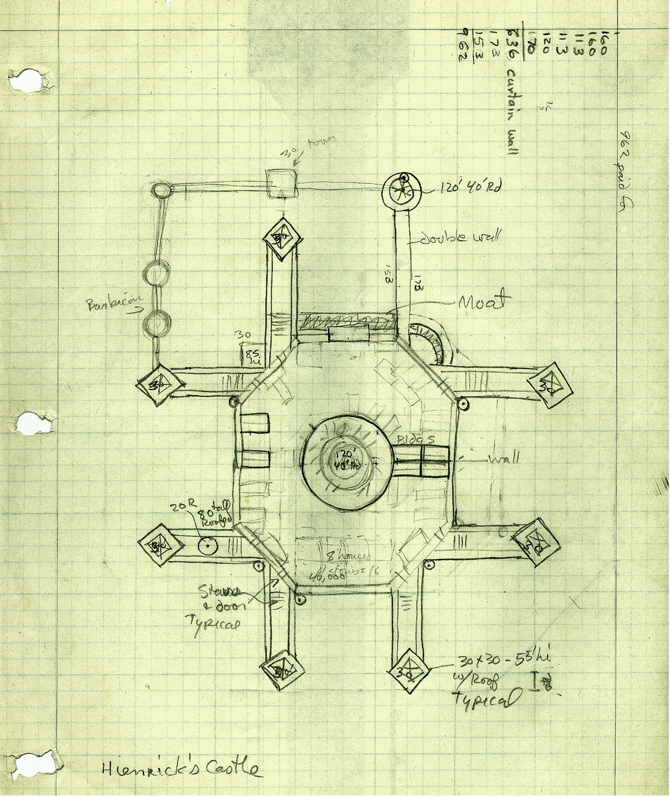
Henrich's Fortress
My posting of my River kingdoms maps brought some memories back from She-Who-Must-be-Obeyed. She has the following to say about Castles and wilderness campaigns:


The first campaign I was in was under the original D& D rules. Wilderness was new then and our ref had bought nine pieces of heavy weight hex paper, each measuring two feet by three feet.And here's a picture of the fortress her fighter Henrich build with the money from the mines:
When we met to play he would lay them out on the carpet and we would sit on the floor to play. It was an impressive graphic which added a lot to the atmosphere of the game. But we liked the map so much we did not go into any dungeon. “We found another treasure map? I sell it to the npc.” Our ref despaired. So once one of my characters made fifth level he persuaded me to found a barony. The thinking here was that it would make me poor and force me to go adventuring in the dungeons to keep solvent. He also had some untried roll-up charts about finding mines in your barony. Long story short the mines made me wealthy and I never did set foot in a dungeon while in his campaign.
I remember asking about trade. I had to include an existing road and buy a company. My notes include comments about making and selling carts at 100 gold each and buying cart horses for 30 gold each from another player. I had seven villages, five of humans, one of elves, but the one village on the road was composed of dwarfs. After that every cart driver we encountered was a dwarf.
This campaign is the only one I have played in where I created a stronghold. I had to not only draw up the fortress but also compose a coat of arms for my character and keep the monthly books. My mage decided to work a deal with my fighter so he could put up a tower within the patrolled land and not need to go through the agony of clearing land, keeping troops or making me keep more books. I also had a cleric and he settled next to my friend who played the dwarf king up on Frog Island. The king (and his army) graciously accompanied my cleric while land clearing. When the ref rolled up the races in my villages his bemused look attracted our attention. “They are ALL dwarfs.” He told us.

New Blog Layout
Yeah you caught me. I've been playing with blogger rather than writing cool posts. Now back to work...
Subscribe to:
Posts (Atom)